Union Square (New York City)
From Wikipedia, the free encyclopedia
| Union Square | |
|---|---|
| U.S. National Register of Historic Places | |
| U.S. National Historic Landmark | |
 Union Square
|
|
| Location: | New York, NY |
| Built/Founded: | 1882 (laid out c.1832)[1] |
| Architect: | Frederic Auguste Bartholdi; et.al. |
| Governing body: | New York City Department of Parks and Recreation |
| Added to NRHP: | December 9, 1997[2] |
| Designated NHL: | December 9, 1997[3] |
| NRHP Reference#: | 97001678[2] |
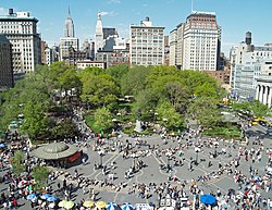
Union Square is an important and historic intersection in New York City, located where Broadway and the Bowery came together in the early 19th century; its name does not celebrate the federal union but rather denotes the fact that "here was the union of the two principal thoroughfares of the island"[4] and the confluence of several trolley lines, as in the term "union station." Today it is bounded by 14th Street to the south, Union Square West on the west side, 17th Street on the north, and on the east Union Square East, which links together Broadway and Park Avenue South to Fourth Avenue and the continuation of Broadway. Union Square Park is under the aegis of the New York City Department of Parks and Recreation.
Neighborhoods around the park are the Flatiron District to the north, Chelsea to the west, Greenwich Village and New York University to the south, and Gramercy to the east. Also nearby is The New School. The eastern side of the square is dominated by the Zeckendorf Towers, the south side by One Union Square (1999) voted New York's Ugliest Building by a panel of architects assembled by the New York Post. It features a kinetic wall sculpture and digital clock expelling bursts of steam, titled Metronome.
Union Square is noted for its impressive equestrian statue of George Washington, modeled by Henry Kirke Brown and unveiled in 1856, the first public sculpture erected in New York since the equestrian statue of George III in 1770 and the first American equestrian sculpture cast in bronze. Other statues in the park include the Marquis de Lafayette, modeled by Frédéric-Auguste Bartholdi and dedicated at the Centennial, July 4, 1876, Abraham Lincoln, modeled by Henry Kirke Brown (1870), and the James Fountain (1881), a Temperance fountain with the figure of Charity who empties her jug of water, aided by a child; it was donated by Daniel Willis James and sculpted by Adolf Donndorf. A newer addition is a statue of Mahatma Gandhi in the southwest corner of the park, added in 1986, to mark Union Square's history of social activism.
Contents |
[edit] Subways
Union Square lies over 14th Street–Union Square, a New York City Subway complex served by the 4, 5, 6, L, N, Q, R, and W trains.
[edit] History


In 1815, by act of the state legislature, this former potter's field became public commons for the city.[5] In 1832, the corporation determined to enlarge its area to 17th Street on the north and extend the axis of University Place to form the square's west side. A fountain was built in the center of Union Square to receive the water from the Croton Aqueduct, completed in 1842. In 1845, $116,000 was spent in paving the surrounding streets and planting the square, in part owing to the encouragement of Samuel B. Ruggles, one of the founders of the Bank of Commerce, who had developed Gramercy Park, to the northeast. In early years the square's central oval planted with radiating walks lined with trees was surrounded by a fence. At first the Square was largely residential; the Union League Club first occupied a house loaned for the purpose by Henry G. Marquand at the corner of 17th Street and Broadway. In 1872 Frederick Law Olmsted and Calvert Vaux[6] were called in to replant the park, as an open glade with clumps of trees.
Union Square, having become largely commercial, began to lose social cachet at the turn of the twentieth century. Tiffany & Co., which had moved here from Broadway and Broome Street in 1870, left its premises on 15th Street to move uptown to 37th Street in 1905; the silversmiths Gorham Company moved up from 19th Street in 1906. The last of the neighborhood's free-standing private mansions, Peter Goelet's at the northeast corner of 19th Street, made way for a commercial building in 1897.
[edit] Site of social and political activism

The park has historically been the start or the end point for many political demonstrations. In April 1861, soon after the fall of Fort Sumter, it was the site of a patriotic rally of perhaps a quarter of a million people that is thought to have been the largest public gathering in North America up to that time.
Union Square is, and was, a frequent gathering point for radicals of all stripes to make speeches or demonstrate. On September 5, 1882, in the first Labor Day celebration, a crowd of at least 10,000 workers paraded up Broadway and filed past the reviewing stand at Union Square. Although the park was known for its union rallies and for the large 1861 gathering in support of Union troops, it was actually named in the 18th century for its location at the "union" of Bloomingdale Road (now Broadway) and Eastern Post Road (now extinct) decades before these gatherings.[7]
Union Square was named a National Historic Landmark in 1997, primarily to honor it as the site of the first Labor Day parade.[3][8],[9]
In the days and weeks following the September 11, 2001 terrorist attacks, Union Square became a primary public gathering point for mourners. People created spontaneous candle and photograph memorials in the park and vigils were held to honor the victims. This was a natural role for the Square as Lower Manhattan below 14th Street, which forms Union Square's southern border, briefly became a "frozen zone," with no non-emergency vehicles allowed and pedestrians sometimes stopped and asked why they were venturing south by police and national guardsmen. In fact, for the first few days following the attacks, only those who could prove residency below 14th Street could pass. The Square's tradition as a meeting place in times of upheaval was also a factor.
[edit] Greenmarket and local businesses

In 1976, the Council on the Environment of New York City established the Greenmarket program, which provided regional small family farmers with opportunities to sell their fruits, vegetables and other farm products at open-air markets in the city. The most famous is the Union Square Greenmarket, held Mondays, Wednesdays, Fridays, and Saturdays between 8 AM and 6 PM year round. 250,000 customers a week purchase 1,000 varieties of fruits and vegetables at the market.[10] The variety of produce available is broader by perhaps a factor of ten than what is found in a conventional supermarket.[11]
Union Square is also known for the Union Square Holiday Market, which is held November 23 through December 24. Temporary kiosks are filled by over 100 artisans, who sell items ranging from candles and perfume to knitted scarves and high-end jewelry.
Union Square is a popular meeting place, given its central location in Manhattan and its many subway lines. There are many bars and restaurants on the periphery of the square, and the surrounding streets have some of the city's most renowned (and expensive) restaurants. S. Klein's department store promoted itself in the middle 20th century as an "On the Square" alternative to higher prices uptown, and late in the century several big-box chain stores established a presence, including Barnes & Noble, Babies "R" Us, Staples and Circuit City. In addition, the W Union Square Hotel opened at the park's northeast corner, in the landmark building that formerly housed the Guardian Life Insurance Company of America.
[edit] Union Square Partnership

The Union Square Partnership (USP), a Business Improvement District (BID) and a Local Development Corporation (LDC), was formed in 1984 and became a model for other Business Improvement Districts in New York City. It had, as of 2006, a US$1.4 million budget. Jennifer E. Falk became its executive director in January 2007.[12]
- Controversy
The Union Square Partnership filed a DMCA takedown notice, a copyright lawsuit, and a complaint with the WIPO against a web site created by Savitri Durkee.[13] The Electronic Frontier Foundation defended Durkee on the grounds that the web site was a parody protected by free speech. The case was settled out-of-court [14] and the parody web site has returned as http://www.unionsquarepartnershipsucks.org/.
[edit] The North End Renovation
In March 2008, an 18-month renovation began on the northern end of the park. Proponents of the plan describe it as the completion of a renovation of Union Square Park that began in the mid-1980's that will improve the park by increasing the amount and quality of playground space, improving the quality and function of the public plaza, rehabilitating the badly deteriorating bandshell structure, improving the working conditions for park employees, and maintaining the "eyes on the street" presence of a restaurant at the heart of the park. Protests and political action in response to the original renovation plans resulted in a reduction in the degree to which the pavilion was to be renovated, a reduction in the total amount of space that the restaurant would occupy, and an increase in the amount of dedicated play space, but stiff opposition remains to the idea that any commercial uses might occupy the pavilion. Despite the fact that the overall amount of play space in the park will be increased as a result of the renovation, those critical of the plan claim that the bandshell pavilion itself ought to be converted to play space.[15][16] The fate of the historic pavilion building is uncertain and has been brought before the State Supreme Court.[17][18] On March 30, 2009, a judge threw out the lawsuit against the renovation, paving the way for a seasonal restaurant in the pavillion.[19]
One element of contention not related to the restaurant concession is the inclusion of a single line of street trees, spaced 30 feet apart, along the north side of the plaza. Despite rumors to the contrary, the inclusion of trees was made possible without reducing the usable gathering space of the plaza by the simultaneous decision to remove a painted median strip that had separated eastbound and westbound traffic along 17th Street, thus increasing the northern limits of the plaza by several feet. Some critics feel that this line of trees will make the space less useful for large rallies although no barriers to free movement across 17th street are being introduced and the "temporary" metal rails, welded together to make a continuous fence along the north side of the site, will be removed as part of the renovation of the plaza. A double line of trees along 17th street had been planted years earlier as a monument to victims of the Armenian Genocide. It is unclear whether the new line of trees will take on a similar memorial status.
During the renovation the Green Market was temporarily relocated to the west side of the park, returning to the north end as of April 4, 2009.
[edit] Gallery
 |
 |
 |
 |
 |
 |
 |
 |
[edit] See also
[edit] Notes
- ^ "About the City of New York: Parks for the New Metropolis (1811-1870)". http://www.nycgovparks.org/sub_about/parks_history/historic_tour/history_new_metropolis.html. Retrieved on 2008-03-27.
- ^ a b "National Register Information System". National Register of Historic Places. National Park Service. 2007-01-23. http://www.nr.nps.gov/.
- ^ a b "Union Square". National Historic Landmark summary listing. National Park Service. 2007-09-20. http://tps.cr.nps.gov/nhl/detail.cfm?ResourceId=1502083784&ResourceType=Site.
- ^ Stephen Jenkins, The Greatest Street in the World (The Story of Broadway, Old and New (1911)
- ^ This section depends on material in Stephen Jenkins, The Greatest Street in the World: The Story of Broadway, Old and New, (1911)
- ^ Olmsted and Vaux were carrying out their plan for Central Park; their plan, and the original plan, are represented in bronze plaques with very low relief, set into the sidewalks near the southwest and southeast corners.
- ^ Union Square: New York City Department of Parks and Recreation. Retrieved December 12, 2006
- ^ ["Union Square", March 6, 1996, by John W. Bond "National Historic Landmark Nomination"]. National Park Service. 1996-03-06. "Union Square", March 6, 1996, by John W. Bond.
- ^ [Union Square—Accompanying photos from 1995-1997 and illustration from 1882. "National Historic Landmark Nomination"]. National Park Service. 1996-03-06. Union Square—Accompanying photos from 1995-1997 and illustration from 1882..
- ^ "Greenmarket Facts". http://www.cenyc.org/site/pages/GMKT/GMKTfacts.htm. Retrieved on 2007-08-04.
- ^ Fishman, Steve. "Manhattan Gets Fresh". http://nymag.com/nymetro/news/anniversary/35th/n_8592/. Retrieved on 2007-08-04.
- ^ Erik Enquist "BID executive makes plans for progress" Crain's New York Business (17 January 2007)
- ^ EFF "Bogus IP Claims Quash Debate Over Future of NYC Landmark" (18 November 2008)
- ^ EFF "USP v. Durkee" (Retrieved on 24 February 2009)
- ^ "Opponents pile on Union Sq. pavilion plan at rally". http://www.thevillager.com/villager_189/opponentspileonunionsq.html. Retrieved on 2008-05-27.
- ^ "Groups Protest Planned Restaurant In Union Square Park". http://www.ny1.com/ny1/content/index.jsp?stid=1&aid=54305. Retrieved on 2008-05-27.
- ^ "Judge Extends Injunction Against Union Square Restaurant". http://www.ny1.com/ny1/content/index.jsp?stid=1&aid=80963. Retrieved on 2008-05-27.
- ^ "Union Sq. work restart O.K.’d, but pavilion is on back burner". http://www.thevillager.com/villager_263/unionsquare.html. Retrieved on 2008-05-27.
- ^ "Judge throws out suit against Union Square renovation and seasonal restaurant". http://www.nypost.com/seven/03312009/news/regionalnews/union_sq__eatery_okd_162171.htm.
[edit] External links
| Wikimedia Commons has media related to: Union Square |
- A History of Union Square, on the New York City Department of Parks & Recreation website
- Photograph of Union Square taken in September 2001, showing flowers and candles left in memory of 9/11 victims
- CENYC Greenmarket Farmer's Markets Official Site
- The Metronome: Information about the LED display that shows a running number in the south part of Union Square
- NYCfoto.com Photos of Union Square
|
||||||||||


